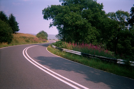
Climbing the Devil's Beeftub

This is primarily designed as a cycle tour of Scotland however it is equally valid for travellers by car or motorbike. The Stages breaks down the tour into day sized stages. Doing the complete Tour will take the average cyclist two weeks. Some of the Stages are short, almost time trial in nature, while others are long days in the saddle. No day is over the hundred miles however! The focus of the tour is the mountains, not just the Highland scenery, but the climbs along the way. The mountain climbs are all catagorised to give the rider a feel for what is in store during the day.
The lend themselves well to the tourer with a car who can sample the best bits of the Tour. Alternatively the cyclist can treat them as individual day rides to be sampled at leisure. However they are taken, they provide some of the best and most challenging riding that Scotland has to offer.
It is also worth bearing in mind the weather in Scotland. It can be very hot during the Summer, particularly in May and June, but it can equally be wet and cold. Unfortunately for the tourist this can happen on the same day! It is worth therefore planning your tour with care. Choose suitable accommodation for overnight stays. If you are carrying everything with you on the bike then make sure you have suitable clothing for all weathers. If you have a back-up bus then ensure you can get you stuff on and off the bus easily.
The categories are defined for the direction of ascent given in the book.
Before the start of the climb, be conscious of your gearing. Get in a high gear for as long as possible beforehand. This conditions your legs to turning at a slow pace under pressure. As you feel the gradient start, drop to a medium gear and ride this until it starts to slow. The secret is to keep a rhythm; you do notwant to stall in too high a gear, but you want to save a gear or to for nearer the top. If you loose momentum, its okay to get out the saddle and pick up speed, then drop back into the saddle and pick up the rhythm. As the summit nears you can start to focus on it and feel the elation as you pull over the top. Unless you are completely exhausted, you should try to keep going for a bit rather than stopping abruptly. This will allow the lactic acid to be flushed out of your muscles and stop you getting sore legs.
Check the Midge Forecast before you go

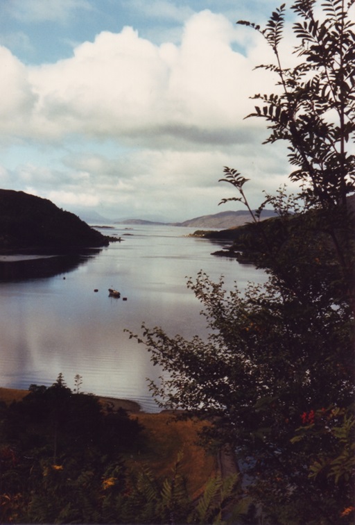
Climbing the Devil's Beeftub
| Distance (Miles) | Description |
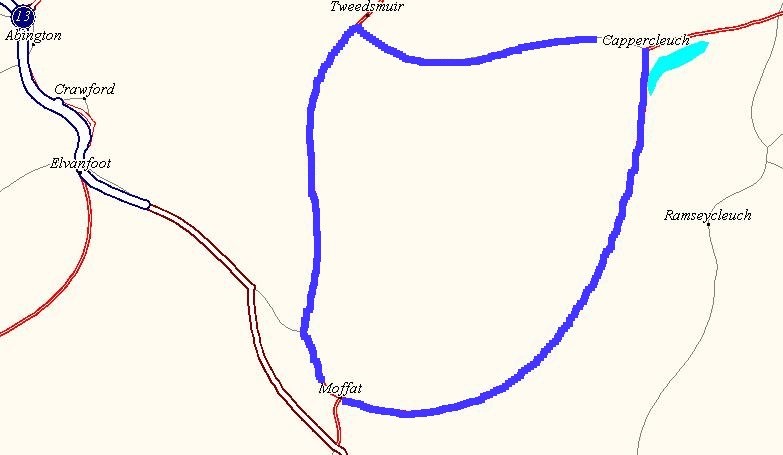
| 0.0 | Leave Moffat on the A701 heading north towards Edinburgh. The category 1 climb starts immediately on leaving the town |
| 4.0 | The summit of the "Devil's Beeftub" (375mm). Category 1 Climb 302m |
| 12.5 | Turn right off the A701 just before Tweedsmuir |
| 16.0 | Summit of "Meggithead" (452m) |
| 22.0 | Cappercleugh |
| 39.0 | Moffat (Finish) |

Climbing up to Wanlockhead
| Distance | 72 Miles |
| Altitude | 3061 ft |
| OS MAPS | 78 & 71 |
| Dificulty Rating | 3 |

| Distance (Miles) | Description |
| 0.0 | Moffat (105m). Leave town heading south west on the A701 for 3 miles |
| 2.0 | At the roundabout take the old A74 (now a national cycle route) heading north. |
| 9.0 | Beattock Summit (314m). Category 1 climb. (209m). |
| 18.4 | Elvanfoot. Turn left onto the A702 heading south towards Durisdeer. (there are signs for Drumlanrig Castle). |
| 25.1 | Summit of Dalveen Pass (345m). |
| 30.0 | Turn right at Holestane Farm. (Morton Castle on left). Follow signs for Drumlanrig Castle. |
| 31.0 | Turn right onto the A76, heading north towards Mennock. (Drumlanrig is straight ahead at this junction.) |
| 41.8 | In Mennock, turn right onto the B797 heading east towards Wanlockhead. |
| 48.5 | Carry on through Wanlockhead. |
| 49.0 | Reach the summit of the climb (466m). There is a cattle grid at the local district boundary. |
| 50.1 | Carry straight through Leadhills, keeping left on main road (B797). |
| 53.1 | Bear left onto a local road rising steeply. Marked Crawfordjohn |
| 54.5 | Climb over the summit of Pyatshaw Brae (366m) and decend into Crawfordjohn |
| 56.3 | Turn left at the T junction in Crawfordjohn onto the B740 towards Sanquhar for 2 miles |
| 58.0 | Turn right onto a local road heading north west to Glespin for 6 miles |
| 63.6 | Turn left onto the A70 for 8 miles heading west towards Cumnock & Murkirk |
| 72.0 | In Muirkirk, turn right onto the B743 towards Strathaven for 14 miles. Climb to the summit of Dumgavel (277m). The the long descent to Strathaven. |
| 86.0 | Finish in Strathaven |

The picturesque town of Largs is today's finish
| Distance | 55 Miles | Altitude | 2037 ft |
| OS MAPS | 71, 70 & 63 | Dificulty Rating | 2 |

| Distance (Miles) | Description |
| 0.0 | Leave Strathaven on the B743 for 1 mile to reach the A71 |
| 1.2 | Turn right onto the A71 towards Darvel for 1 mile |
| 2.2 | Turn right onto a local road at bend in the A71. Follow road till cross roads |
| 4.6 | Turn right at cross roads heading towards Eaglesham for 12 miles. Pass Ardochrig farm. |
| 8.6 | Turn left at cross roads. 90 degree turn right after 1 mile. |
| 10.5 | Turn left. 90 degree bend after 1 mile. Go straight through cross roads. |
| 13.1 | Turn left at Y junction. |
| 16.3 | Turn left onto the B764 and head over the summit of Fenwick Moor. Ballageich Hill (974ft) |
| 22.5 | Join the A77 for 4 miles |
| 26.2 | Leave the A77 at the Fenwick exit |
| 26.7 | In Fenwick turn right and head under the A77. At the roundabout carry straight on onto the B778 heading towards Stewarton |
| 30.1 | In Stewarton turn left down main street for ¼ of a mile. |
| 30.3 | Turn right onto the B778 for 4 miles heading west |
| 34.0 | Turn right onto the A736 and up through Auchentiber. |
| 34.7 | Turn left onto the B707 (when leaving Auchentiber) heading west for 4 miles towards Dalry |
| 39.1 | Turn left onto the A737 towards Dalry |
| 40.4 | In the middle of Dalry turn right on the B780 towards (marked Kilbirnie) but turn left onto the B781 to West Kilbride |
| 47.3 | Turn right in West Kilbride and follow road leading down to coast road |
| 48.3 | Turn right onto the A78 heading north |
| 51.8 | Carry on through Fairlie on the A78 |
| 54.7 | Arrive Largs |

The days starts with a climb of the Hayley Brae
| Distance | 80 Miles | Altitude | 2,270 ft |
| OS MAPS | 63, 64 & 57 | Dificulty Rating | 3 |

| Distance (Miles) | Description |
| START | Leave Largs heading south. At the junction with the A760 turn left following signs for Kilbirnie. Category 2 climb Hayleigh Brae (231m). |
| 7 miles | Stay on the A760 for 7.6 miles till Kilburnie.At the roundabout follow signs for Lochwinnoch. |
| 11 miles | Leave the A760 at Lochwinnoch turning left through the town. Take the B786 towards Kilmacolm |
| 12 miles | At Carruth House (in a small wood) turn right towards Bridge of Weir |
| 15 miles | In Bridge of Weir cross the main A761 road and take the B790 to Houston |
| 16 miles | In Houston turn left at the roundabout and take the B789 towards Bishopton. |
| 20 miles | Turn right off the B789 to Bishopton |
| 22 miles | In Bishopton follow signs for the Erskine Bridge |
| 28 miles | Erskine Bridge. Cross the bridge |
| 29 miles | On the north side of the bridge join the busy A82 for a mile. Leave the A82 at the exit for Duntocher and Milngavie. |
| 31 miles | Follow the A810 through Faifley, turning left onto the B8050 to Milngavie |
| 36 miles | In Milngavie, go through the roundabout, follow the road round to the left. |
| 37 miles | Turn left (going back on oneself) at the Y junction. Follow road round to the right. |
| 38 miles | At the bend take the road to the left out to Mugdock resevoir passed on the right. Keep right at the Y junction and keep going to Strathblane |
| 39 miles | Leave Strathblane heading east on the A891 towards Lennoxtown and Kilsyth |
| 43 miles | In Lennoxtown turn left onto the Campsie road (B822) |
| 44 miles | Category 2 climb (1115 ft) Decend the B822 and follow road to Fintry |
| 49 miles | In Fintry bear right on the B822 |
| 52 miles | Pass the Balfron exit and leave the B822 to the left towards Arnprior |
| 54 miles | In Arnprior cross over the A811 and take the B8034 to Port of Menteith |
| 59 miles | In Port of Menteith turn right onto the A873 towards Calender |
| 60 miles | Turn left off the A873. Category 3 climb. (172m) Decend through the woods, follow the road around to the left and enter Callender |
| 65 miles | In Calander do not go up onto the A84 main street, but turn left at the back of the town following the river passed the caravan site to join the A821 at Bochastle |
| 66 miles | Turn left onto the A82. Cycle along the banks of Loch Venachar to reach Bridge of Turk. |
| 71 miles | Cycle round Loch Venachar passed the Hotel and climb up into the Achray Forest |
| 73 miles | Category 2 climb (loch venechar) (860 ft) |
| 80 miles | Decend the Queens View to reach the day's end at Aberfoyle |

Crossing Loch Lomond on the ferry
| Distance | 61 Miles | Altitude | 1,778 ft |
| OS MAPS | 57, 56, 51 & 50 | Dificulty Rating | 2 |

| Distance (Miles) | Description |
| START | Depart Aberfoyle on the B829 heading north west towards Stronachlachar |
| 12 miles | Turn left at the T junction and head down the hill to the hotel and pier at Inversnaid (NN 396 099) |
| 16 miles | At the pier at Inversnaid get the ferry across Loch Lomond |
| 16 miles | On the western shore at Inveruglas turn left heading south onto the A82 |
| 20 miles | n Tarbert, turn right at the T junction with the A83, the hotel is on your left. Follow the road round to the left and over the hill and decend into Arrochar |
| 23 miles | Cycle through Arrochar, follow the road round the top of Loch Long |
| 16 miles | Category 1 Climb. Climb the hill up Glen Croe known as the Rest and Be Thankful. Reach the summit of the Rest and Be Thankful. Take the small road to the left (B828) which rises at first to the summit of the climb (1014ft). The decend into Hell's Glen |
| 29 miles | Take the B839 on the right. Climb to the summit of Hell's Glen (791ft). The descend towards Loch Fyne at Ardno. |
| 33 miles | Turn right onto the A815 at the T junction. |
| 34 miles | Turn left onto the A83 and follow the road round the top of Loch Fyne |
| 44 miles | In Inverary turn right up the hill taking the A819 into Glen Aray, towards Cladich and Dalmally. |
| 50 miles | Climb to the col of Glen Aray (682ft), then descend to Cladich, keeping on the A819 to Dalmally. |
| 55 miles | Turn right onto the A85 and head into Dalmally. Follow the road along Glen Lochy to arrive at Tyndrum |
| 67 miles | Finish in Tyndrum |
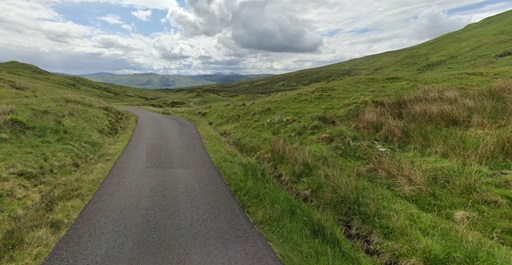
Above Loch Tay on the way to Glen Lyon, near Ben Lawers Visitor Centre.
| Distance | 92 Miles | Altitude | 3.068 ft |
| OS MAPS | 51 | Dificulty Rating | 2 |
| Distance (Miles) | 70 |
| START | Start at Tyndrum at 745 ft. Head south east on the A82 towards Crianlarich. |
| 5 miles | Carry on straight through Crianlarich (600ft), following the A85 |
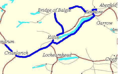
| 14 miles | Turn Left at the A827 (marked for Killin) at the Lix Toll. |
| 20 miles | Follow the river Dochart into Killin (380ft). Carry on through the centre of the town |
| 22 miles | Follow the road round to the right. Loch Tay is on the right. The road rised up on leaving the town and runs parallel to the loch about 250ft above it. |
| 25 miles | Follow the road round to the right. Loch Tay is on the right. The road rised up on leaving the town and runs parallel to the loch about 250ft above it. |
| 28 miles | he road hairpins up the hillside to eventually reach the Ben Lawers visitors centre (1,726ft). The col is reached at 1,969ft. |
| 33 miles | Decend steeply to Bridge of Balgie. Turn right at Bridge of Balgie to follow Glen Lyon eastwards. |
| 45 miles | The farms of Innerwick, Camusvrachan and Invervar are passed before reaching Fortingall. Turn left at the T junction into Fortingall. |
| 49 miles | At T junction with the B846 turn right towards Aberfeldy. |
| 50 miles | Turn right onto the B road to Kenmore. |
| 53 miles | Turn left at the T junction. Loch Tay is now on the right. Go through Kenmore. |
| 54 miles | Turn right at the small road marked for Ardeonaig. Follow this road along the south side of Loch Tay. |
| 71 miles | Turn right onto A827 for ¼ miles |
| 72 miles | At Killin turn left and head out of the town back towards the days start |
| 78 miles | Turn right onto the A85 towards Crianlarich |
| 87 miles | Carry on through Crianlarich towards Tyndrum |
| 92 miles | Arrive in Tyndrum |

The Black Mount

The View Down Glen Coe
| Distance | 113 Miles | Altitude | 3.720 ft |
| OS MAPS | 51, 42 & 40 | Dificulty Rating | 2 |
| Distance (Miles) | 70 |
| START | Depart Tyndrum heading north on the A82 |
| 7 miles | Pass through bridge of Orchy |
| 9 miles | Hill Climb |
| 33 miles | Carry on the A82 passing the village of Glencoe |
| 35 miles | Pass Ballachulish on the A82 |
| 40 miles | Arrive in Onich where the ferry departs across the Corran narrows. At corran on the other side head south towards Strontian. |
| 55 miles | Carry on through Strontian heading west on the A861 |
| 64 miles | Pass the village of Salen |
| 67 miles | Carry on through the village of Acharacle |
| 73 miles | Ardmolich |
| 86 miles | Turn right onto the A830 at Lochailort towards Glenfinnan |
| 95 miles | Glenfinnan |
On The Bealach na Ratagen

The Bealach na Ratagan Summit Views
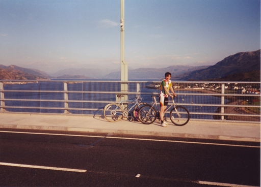
The author on the Skye Bridge
| Distance | 83 Miles | Altitude | 2,392 ft |
| OS MAPS | 41, 34 & 33 | Dificulty Rating | 4 |

| Distance (Miles) | Description |
| START | Depart Fort William heading North on the A82 |
| 10 miles | Continue through Spean Bridge on the A82 |
| 25 miles | In Invergarry turn left onto the A87 towards Kyle of Lochalsh |
| 40 miles | Turn left at the T junction onto the A87 towards Kyle of Lochalsh |
| 60 miles | At Shiel Bridge turn left onto the local road to Ratagan |
| 65 miles | Summit of the Bealach Ratagan |
| 70 miles | In Glen Elg turn right towards the ferry. Take the ferry across to the Isle of Skye |
| 71 miles | Leave Kylerhea heading north |
| 78 miles | Turn right onto the A850 towards Kyleakin |
| 82 miles | Cross the Skye Bridge to Kyle of Lochalsh |
| 83 miles | Arrive Kyle of Lochalsh |

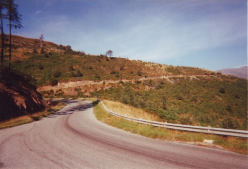
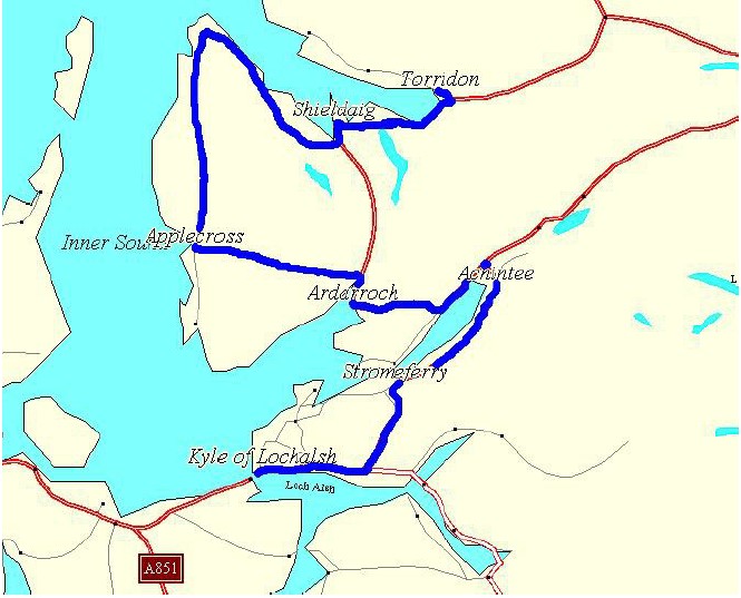
The assent of the Bealach na Ba
| Distance | 74 Miles | Altitude | 5,305 ft |
| OS MAPS | 33 | Dificulty Rating | 4 |
| Distance (Miles) | Description |
| START | Depart Kyle of Lochalsh heading east on the A87 |
| 5 miles | Turn left left onto the 890 heading north towards Strath Carron. Hill Climb |
| 11 miles | Carry on though Stromeferry and cycle along the south side of Loch Carron |
| 19 miles | Carry on through Achintee |
| 20 miles | Turn left onto the A896 heading towards Lochcarron |
| 23 miles | Pass through Lochcarron |
| 30 miles | Turn left onto the Applecross road. Hill Climb |
| 35 miles | Summit of the Bealach na Ba |
| 41 miles | Arrive in Applecross village, carry on through heading north. Carry on round the penisula for 25 miles |
| 66 miles | Pass through the village of Shieldaig |
| 73 miles | Turn left onto the local road to Torridon |
| 74 miles | Arrive in Torridon |
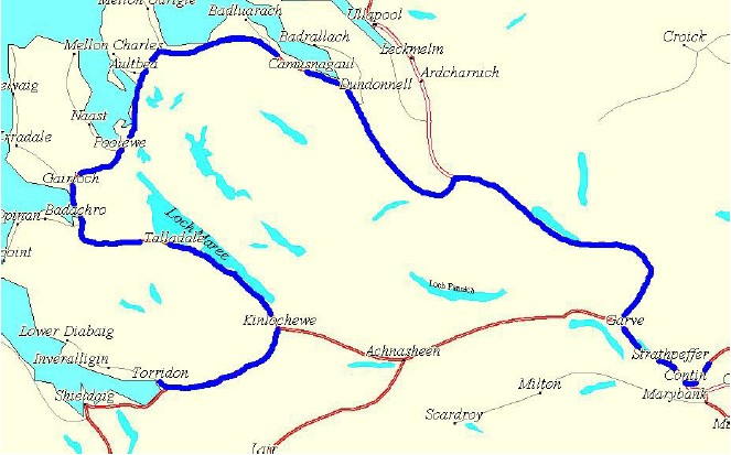
The Beauty of Loch Carron
| Distance | 107 Miles | Altitude | 5305 ft |
| OS MAPS | 24, 25 && 26 | Dificulty Rating | 4 |
| Distance (Miles) | Description |
| START | Depart Torridon heading south on the local road |
| 1 mile | Turn left onto the A896 main road |
| 11 miles | Turn left in Kinlochewe onto the A832 heading north west |
| 44 miles | Pass through the village of Laide |
| 60 miles | Pass through the village of Dundonnell |
| 75 miles | Turn right onto the A835 |
| 104 miles | At Contin turn left onto the A834 towards Strathpeffer |
| 106 miles | Arrive Strathpeffer |
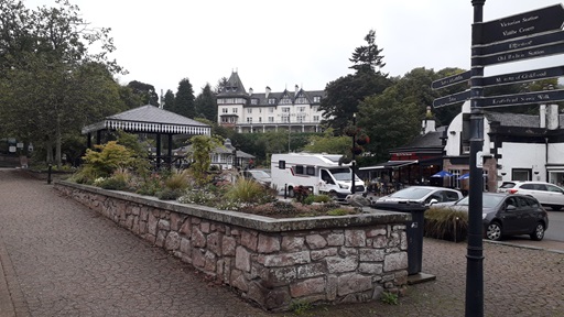
The picturesque victorian spa town of Strathpeffer.
| Distance | 107 Miles | Altitude | 6227 ft |
| OS MAPS | 26, 27 & 43 | Difficulty Rating | 4 |

| Distance (Miles) | Description |
| START | Leave Strathpeffer heading north on the A834 towards Dingwall |
| 5 miles | At Dingwall go onto the A862 |
| 6 miles | Then turn left onto A835 heading south east |
| 12 miles | Go onto the A832 heading east |
| 13 miles | Pass through the village of Tore |
| 13 miles | Turn left onto the A9 towards Inverness |
| 20 miles | Travel through the center of Inverness and take the A96 towards Nairn and the airport |
| 35 miles | Go through the centre of Nairn going right at the roundabout heading towards Elgin and Forres. |
| 36 miles | Bear right onto the A939 towards Grantown on Spey and Ferness |
| 47 miles | Pass through the village of Ferness. Keep on the A939 towards Grantown |
| 60 miles | Pass through Grantown on Spey |
| 62 miles | Turn right onto the A939 towards Tomintoul |
| 83 miles | Carry on through Cock Bridge on the A939 |
| 92 miles | Bear right onto the B976 towards Ballater |
| 98 miles | In Crathie turn onto the main A93 heading west |
| 106 miles | Arrive Braemar |

Where are we today
| Distance | 114 Miles | Altitude | 5121 ft |
| OS MAPS | 43 | Difficulty Rating | 4+ |
| Distance (Miles) | Description |
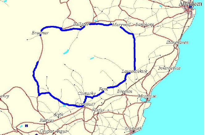
| START | Depart Braemar heading north on the A93 |
| 17 miles | Pass through the town of Ballater heading east on the A93 |
| 28 miles | Turn right onto the B968 heading south |
| 30 miles | Turn left onto the B976 heading east |
| 33 miles | Pass through the village of Marywell |
| 39 miles | Turn right heading south |
| 40 miles | Bear right onto the B974 heading south towards Fettercairn |
| 52 miles | In Fettercairn join the B966 heading west |
| 57 miles | Pass through the village of Edzell |
| 59 miles | Turn right heading south west towards Kirkton |
| 64 miles | Pass through Kirkton heading south west |
| 68 miles | Pass through Fern |
| 71 miles | In Tannadice turn right onto the B957 |
| 78 miles | Pass through Kirriemuir on the B957 |
| 79 miles | Turn left onto the B955 heading south |
| 80 miles | Turn right onto the B951 heading west |
| 82 miles | Pass through Kirkton of Kingoldrum |
| 94 miles | Bear left towards Blacklunans |
| 98 miles | Turn right onto the A93 heading north |
| 105 miles | Pass the turn off for Spittal of Glenshee and begin the climb of the Bealach Ghleann Shidh |
| 114 miles | Arrive summit of Bealach Ghleann Shidh (428m) |

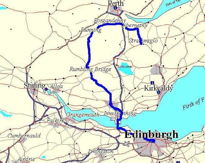
The Lommond Hills on the approach to Strathmiglo
| Distance | 56 Miles | Altitude | 1293 ft |
| OS MAPS | 53, 58 & 59 | Dificulty Rating | 2 |

| Distance (Miles) | Description |
| START | Head south on the Old Military Rd A93 |
| 25 miles | Go through Blairgowrie |
| 40 miles | Go through Scone on the A912 |
| 46 miles | Go through Bridge of Earn on the A912 |
| 47 miles | Begin climb of Glen Farg. |
| 50 miles | Turn left off the A912 at the Bein Inn onto the B996 |
| 52 miles | Cycle through Glenfarg. Summit 148m |
| 54 miles | Turn left onto the A91 and head to Gateside |
| 56 miles | Arrive at Strathmiglo |
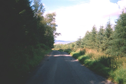
Over the top in Glen Tarkie
| Distance | 62 Miles | Altitude | 3058 ft |
| OS MAPS | 58,65 & 66 | Difficulty Rating | 2 |
| Distance (Miles) | Description |
| START | Heead north out of Strathmiglo taking the Glen Tarkie Road |
| 5 miles | Summit of the Glen Tarkie Road (208m) |
| 9.0 | At Aberargie head west to Dron |
| 11 miles | Take the B985 to Forgandenny |
| 14 miles | Conitue through Forgandenny |
| 19 miles | In Dunning, turn left and head south on the B934 |
| 26 miles | Summit of Dunning Glen (307m) |
| 29 miles | Continue south through Yetts O Muckart |
| 31 miles | Continue south at Powmill on the A823 towards Dunfermline |
| 41 miles | Negotiate Dunfermline, heading towards Inverkeithing, Forth Rd Bridge and Edinburgh |
| 48 miles | Cross the Forth Road Bridge on the cycle path. |
| 53 miles | In South Queensferry follow the B924 towards Edniburgh |
| 62 miles | Arrive at the final destination -the centre of Edinburgh |
